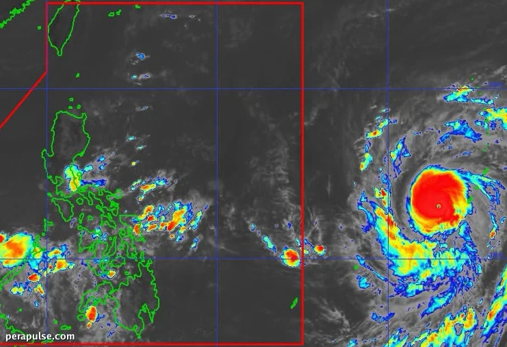
Super Typhoon Champi is on track to enter the Philippine Area of Responsibility (PAR) on October 20, 2026, according to the Philippine Atmospheric, Geophysical, and Astronomical Services Administration (PAGASA).
As of October 18, Champi was located 2,090 kilometers east of southeastern Luzon, moving west at 25 kilometers per hour.
The super typhoon has intensified, boasting maximum sustained winds of 185 km/h and gusts reaching 230 km/h.
Potential Impact in the Philippines
While the likelihood of Champi making landfall in the Philippines is low, PAGASA cautioned that extreme Northern Luzon, including the Batanes and Babuyan Islands, could experience heavy rainfall and strong winds.
Local weather experts predict that upon entering PAR, Champi will be named Rosal, marking the Philippines' 18th tropical cyclone of the year.
The weather bureau may issue tropical cyclone wind signals as early as Monday evening or Tuesday morning, with the highest alerts likely reaching Signal No. 3 or 4.
PAGASA Advisory
- Champi to enter PAR on October 20.
- Heavy rain expected in extreme Northern Luzon.
- Local name will be Rosal upon entry.
In addition to the northern regions, gusty conditions may spread across most of Luzon and parts of the Visayas and Mindanao starting Tuesday.
The current weather systems affecting the Philippines include the intertropical convergence zone (ITCZ) and easterlies, which are causing scattered rain and thunderstorms in several areas.
As the country transitions into the northeast monsoon or amihan, the presence of a strong El Niño may influence weather patterns in the coming months.