Tropical cyclone Mekkhala is predicted to enter the Philippine Area of Responsibility (PAR) late Saturday, June 20, or early Sunday, June 21. As it approaches, the storm is expected to intensify, bringing significant weather changes.
Mekkhala's Path and Intensity
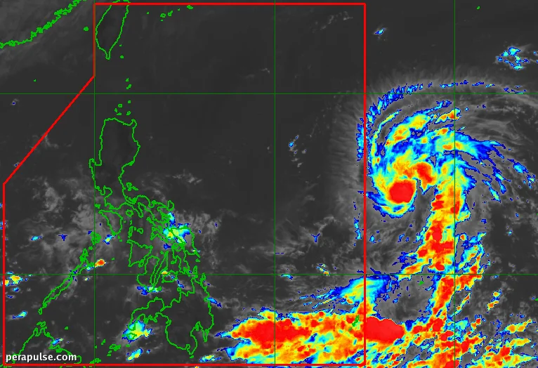
Currently classified as a tropical storm, Mekkhala boasts maximum sustained winds of 85 kilometers per hour, with gusts reaching up to 105 km/h. As of Saturday morning, it was situated 1,590 kilometers east of southeastern Luzon, moving westward at 20 km/h.
A landfall scenario is less likely at this time, but the incoming tropical cyclone could be near land on Tuesday, June 23, and Wednesday, June 24.
PAGASA
- Mekkhala will be known as Francisco upon entering PAR.
- It is the sixth tropical cyclone of 2026 and the second in June.
PAGASA has indicated that the storm's trough may already cause scattered rain and thunderstorms in parts of Eastern Samar, Southern Leyte, Dinagat Islands, and Surigao del Norte.
In the meantime, other regions are expected to experience generally fair weather, though isolated rain showers and thunderstorms could affect Metro Manila and nearby provinces due to the easterlies.
As Mekkhala approaches, PAGASA warns that Signal No. 1 may be raised in the northern and eastern regions of Northern Luzon, with moderate to rough coastal waters anticipated.
The cyclone may also enhance the southwest monsoon or *habagat*, which could lead to heavy rainfall, particularly in the western parts of the country. The onset of the southwest monsoon was officially announced on May 30.