Isang low pressure area (LPA) na matatagpuan 180 kilometro kanluran ng Bacnotan, La Union, ay inaasahang magiging isang
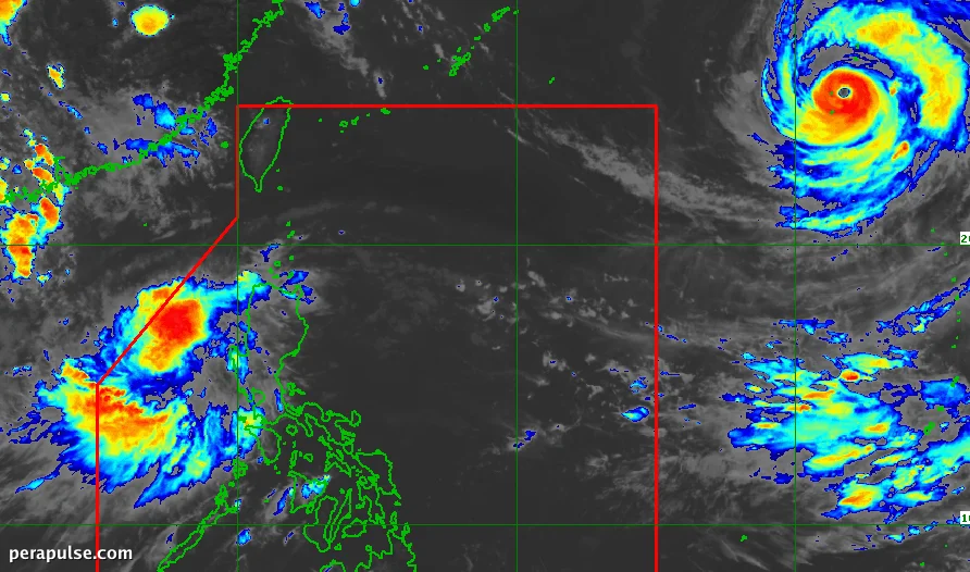
Isang low pressure area (LPA) na matatagpuan 180 kilometro kanluran ng Bacnotan, La Union, ay inaasahang magiging isang tropical depression sa loob ng 24 na oras, ayon sa Philippine Atmospheric, Geophysical, and Astronomical Services Administration (PAGASA).
Nakatakdang Pag-ulan at Panganib ng Baha
Habang ang LPA ay kumikilos patungong silangan, inaasahang magdadala ito ng makabuluhang pag-ulan sa ilang rehiyon, partikular sa
Habang ang LPA ay kumikilos patungong silangan, inaasahang magdadala ito ng makabuluhang pag-ulan sa ilang rehiyon, partikular sa Ilocos Region, Cordillera Administrative Region, Cagayan Valley, at Central Luzon.
Ang pagbaha at pagguho ng lupa ay mga alalahanin sa mga lugar na ito dahil inaasahang magiging matindi ang pag-ulan.
Kung ang LPA ay magiging tropical depression, ito ay papangalanang Maymay, na magiging ika-13 na tropical cyclone ng Pilipinas sa taon na ito.
(cite: PAGASA Weather Specialist Benison Estareja)
Dagdag pa rito, ang southwest monsoon, o *habagat*, ay inaasahang magpapalakas ng pag-ulan sa Metro Manila, Calabarzon, Mimaropa, at mga bahagi ng Kanlurang Visayas.
Habang umuusad ang sitwasyon, ang mga residente sa mga apektadong lugar ay pinapayuhan na gumawa ng mga kinakailangang pag-iingat, lalo na sa potensyal na malakas na ulan mula sa parehong
Habang umuusad ang sitwasyon, ang mga residente sa mga apektadong lugar ay pinapayuhan na gumawa ng mga kinakailangang pag-iingat, lalo na sa potensyal na malakas na ulan mula sa parehong LPA at ang southwest monsoon.
Ang Bagyong Dolphin, na matatagpuan 2,095 kilometro silangan-hilagang-silangan ng Hilagang Luzon, ay maaari ring makaapekto sa mga sistema ng panahon, dahil inaasahang palalakasin nito ang southwest monsoon simula Agosto 6.
Sa kasalukuyan, ang Pilipinas ay nakakaranas na ng aktibong panahon ng bagyo, patuloy na minomonitor ng ahensya ng panahon ang mga kaganapan.