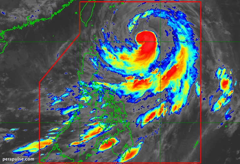
Humihina si Bagyong Inday (Bavi), ngunit ang mga epekto nito ay mararamdaman pa rin sa buong Pilipinas habang lumalakas ang timog-kanlurang monsoon. Noong Hulyo 10, 2026, ang bagyo ay matatagpuan sa 620 kilometro silangan ng
Humihina si Bagyong Inday (Bavi), ngunit ang mga epekto nito ay mararamdaman pa rin sa buong Pilipinas habang lumalakas ang timog-kanlurang monsoon. Noong Hulyo 10, 2026, ang bagyo ay matatagpuan sa 620 kilometro silangan ng Basco, Batanes, at kumikilos patungong hilagang-kanluran sa bilis na 20 kilometro bawat oras.
Taya ng Ulan at Mga Apektadong Lugar
Nagbabala ang Philippine Atmospheric, Geophysical, and Astronomical Services Administration (PAGASA) tungkol sa makabuluhang pag-ulan, partikular sa Hilagang Luzon. Ang Batanes ay nakakaranas na ng katamtaman hanggang sa malakas na ulan, tinatayang nasa 50-100 milimetro.
Inaasahang magdudulot ang pag-ulan ng potensyal na pagbaha at pagguho ng lupa, lalo na sa mga bulubundukin.
Mga Signal ng Hangin at Kalagayan ng Dagat
Noong umaga ng Biyernes, itinaas ng PAGASA ang mga signal ng hangin ng tropikal na bagyo sa ilang lugar. Ang Batanes at mga bahagi ng mga Isla ng Babuyan ay nasa ilalim ng Signal No. 2, na nagpapahiwatig ng malalakas na hangin.
Inaasahang magiging mapanganib ang kalagayan ng dagat, na may mga alon na umaabot ng hanggang 7 metro sa ilang lugar. Pinapayuhan ang mga manlalakbay na mag-ingat.
Mga Hinaharap na Proyeksyon para kay Inday
Matapos makipag-ugnayan sa Hilagang Luzon, inaasahang tutungo si Bagyong Inday patungo sa mga timog na isla ng Japan at maaaring tumama sa lupa malapit sa Taiwan bago malamang lumabas sa Philippine Area of Responsibility (PAR) sa Hulyo 12.
Si Inday ay ang ikasiyam na tropikal na bagyo ng Pilipinas sa 2026 at itinatampok ang patuloy na hamon na dulot ng mga sistemang tropikal na panahon sa panahon ng tag-ulan.