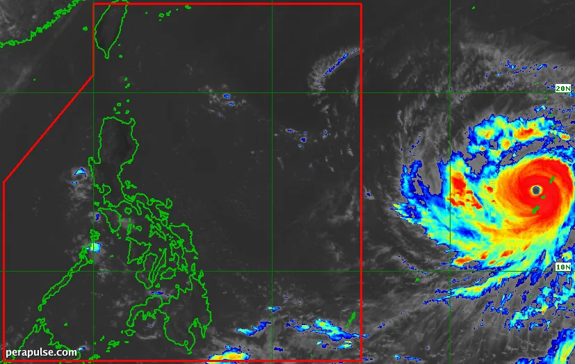
Ang Super Typhoon Bavi ay nasa tamang landas upang pumasok sa Philippine Area of Responsibility (PAR) sa pagitan ng gabi ng Hulyo 7 at umaga ng Hulyo 8, 2026. Matatagpuan 2,215 kilometro silangan ng timog-silangang Luzon, ang Bavi ay umuusad patungong kanluran-hilagang kanluran sa bilis na 20 kilometro bawat oras.
Potensyal na Epekto sa Pilipinas
Sa kasalukuyan ay may maximum na pinapanatili na hangin na 205 km/h at mga bugso na umaabot sa 250 km/h, inaasahang makakaapekto ang Bavi sa mga pattern ng panahon sa buong Pilipinas, kahit na hindi ito tumama sa lupa. Napansin ng PAGASA na ang posibilidad na direktang maapektuhan ng bagyo ang lupa ay mababa, kung saan ang Taiwan at mga Pulo ng Ryukyu sa Japan ay maaaring maging mga target.
Dahil sa kawalang-katiyakan sa radius ng malalakas na hangin, hindi maalis ang posibilidad na magtaas ng mga signal ng hangin sa mga silangang bahagi ng Timog Luzon at Visayas.
(cite: PAGASA)
Inaasahan ng PAGASA na maglalabas ng mga signal ng hangin para sa mga hilaga at silangang bahagi ng Hilagang Luzon simula Hulyo 7 o 8. Ang ahensya ay naghahanda ring maglabas ng babala sa malalakas na alon, na nagtataya ng magaspang na kondisyon ng dagat sa hilaga at silangang baybayin.
Habang papalapit ang Bavi, lalakas ang southwest monsoon, na magiging sanhi ng mga malalakas na kondisyon sa buong bansa at pagtaas ng pag-ulan, partikular sa mga hilaga at kanlurang lalawigan.
Ang super typhoon na ito ay ang ikasiyam na tropical cyclone para sa Pilipinas sa 2026 at ang pangalawa para sa Hulyo. Inaasahan ng PAGASA na dalawa hanggang apat na karagdagang bagyo ang maaaring mabuo o pumasok sa PAR ngayong buwan.